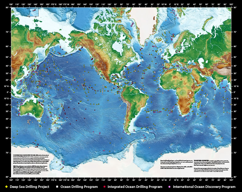
IODP, ODP, and DSDP Site Map Poster
This map is based on a color-shaded relief map produced by the National Oceanic and Atmospheric Administration (NOAA) National Centers for Environmental Information (NEIC, previously NGDC). The following text explaining the history of the program is included on the poster.
THE INTERNATIONAL OCEAN DISCOVERY PROGRAM (IODP), the fourth international marine research drilling program (2013–2023), is dedicated to advancing scientific understanding of Earth processes by sampling and observing subseafloor environments using novel sensors and experimental techniques. Today, scientists are expanding deep-sea research by using multiple drilling platforms to explore IODP’s principal themes: climate, deep biosphere, planetary dynamics, and geohazards.
IODP drilling platforms are operated by the JOIDES Resolution Science Operator (JRSO) at Texas A&M University, Japan’s Center for Deep Earth Exploration (CDEX; Chikyu), and the European Consortium for Ocean Research Drilling (ECORD; mission-specific platforms). IODP is supported by the U.S. National Science Foundation (NSF), Japan’s Ministry of Education, Culture, Sports, Science, and Technology, ECORD, The People’s Republic of China, the Australia/New Zealand Consortium, Brazil, Korea, and India.
Download 44 × 35 inch poster (PDF; 51 Mb)
For additional information on scientific ocean drilling, please contact:
International Ocean Discovery ProgramTexas A&M University
1000 Discovery Drive
College Station TX 77845
USA
information@iodp.tamu.edu
http://iodp.tamu.edu/
Tel: (979) 845-2673